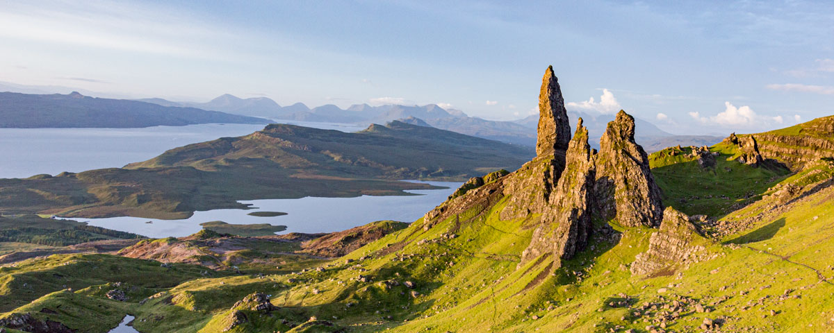

Two Cuillin ranges dominate the landscape on Skye: the Black Cuillin and the Red Cuillin separated by Glen Sligachan.
The iconic ridge of the Black Cuillin is the UK’s most challenging mountain range. Over 11 kilometres long and above 3,000 feet in places, the ridge contains 11 Munros and 16 other summits. The highest point is Sgurr Alasdair at 3,254.59 feet. The gentler, rounded Red Cuillin are popular with hillwalkers, the highest point being Glamaig, a 2,543-foot Corbett.


Landscape & Geology
The Black Cuillin Ridge was formed 60,000,000 years ago and is all that remains of an eroded magma chamber of a huge volcano. Comprised mainly of hard, rough gabbro rock and smoother basalt the ridge was sculpted into its current form by glacial activity and subsequent weathering over the millennia, which created the unique jagged character of the Ridge. The Red Cuillin are mainly made up of granite which was less resistant to the glaciers than gabbro, hence the rounded appearance of the hills.
Safety
The mountains produce wetter and windier weather than elsewhwere on the Island and it will be 4-5 degrees colder on the summits than at sea level. The weather can also be very unpredictable and never assume it will remain the same from the time you set off to the end of your day. The Ridge of the Black Cuillin comprises extremely rough terrain, boulder hills, steep scree slopes and knife-edge ridges, suitable for only experienced climbers. The Red Cuillin, although less challenging, contain areas of steep, rocky terrain.
Before setting off, plan your route carefully by using a reliable map. Make sure you leave a note of your route with a responsible person, with the time you expect to set off and a time you expect to be back. It is a good idea to take a mobile phone with you but be aware that GPS and mobile signals can vary in strength on the mountains and there is no signal at all in some places.
For a visit to either the Black or Red Cuillin, as a minimum, the following hillwalking kit is required:
- a pair of strong, waterproof boots
- a full set of waterproof clothing
- hat and gloves
- a spare layer of warm clothing
- food and water
- map and compass
For the Black and Red Cuillin, the following minimum skills are required:
- Good scrambling and climbing skills
- Good map reading ability
- Ability to use a compass (the rock has a high iron content so your compass may well give faulty readings)
The Black Cuillin is an Alpine mountain range, suitable for climbing and not walking, with a large number of hazards unique to any other mountains in the UK. In addition to the above, tackling any part of the Ridge will require good scrambling/climbing skills, some abseiling experience, and good experience in route finding through steep, rocky terrain. There is no natural supply of water on the ridge so it is strongly advised to take along a good supply of drinking water.
Essential Maps
OS Map - South Skye (Landranger 32)
OS Map - Cuillin Hills (Explorer 411)
There are plenty guide books covering safety on the Cuillin. If you are inexperienced or unsure, hire a guide.
Top Ten Routes
Although the Cuillin offer many great walks and climbs, we have listed 10 of the best, from the easiest first to the toughest challenge the mountains have to offer. A map is essential to find your way to any of these locations and plan your route. Because of the nature of the terrain, none of these walks or climbs should be attempted in very wet conditions.

1. Rubh’ an Dùnain
In the shadow of the spectacular Cuillin Ridge, a pleasant walk from Glenbrittle campsite leads to the headland of Rubh' an Dùnain – 'headland of the fort.' Rising to 98 feet above sea level, 8,000 years of Mesolithic, Neolithic, Viking and Medieval history as well as the Highland Clearances can be explored here, evidence of which can be found in a number of archaeological sites dotted around the peninsula. To the north there are remains of a Neolithic settlement, complete with evidence of round houses, a chambered cairn and a passage tomb. To the south lie the remains of a medieval hillfort. To the east by Loch na h-Airde there are remains of a Viking canal. For wildlife lovers, seals, otters and basking sharks are regular visitors to Loch Brittle and the Sound of Soay.
- Distance: 12km round trip
- Average time: 3-5 hours
- Difficulty: Walk
- Starting point: Glenbrittle campsite. This is a remote area and emergency services are far away. Although there is a track around the peninsula, there are no paths to the sites and the area can be very boggy.
- Additional reading: Isle of Skye | Pathfinder (page 59)

2. Coire Lagan
This 8km round-trip runs from Glenbrittle beach to 600 metres above sea level to a beautiful mountain loch surrounded by Skye’s highest peaks.
- Distance: 4km
- Average time: 1 ½ to 2 hours
- Difficulty: moderate walk
- Starting point: Glenbrittle campsite
- Safety tips: The path is rough and indistinct in places with one short scramble section. This is a great choice of walk in good weather but it is advised not to explore beyond the loch unless you have good scrambling skills.
- Additional reading: 40 Coast & Country Walks (page 54) or Walking the Isle of Skye (page 155)

3. Loch Coruisk
A short boat trip from Elgol will take you over to Loch Coruisk where you can spend a couple of hours exploring the area around the landing jetty or take the 6km route around Loch Coruisk. This is one of the wildest lochs in Scotland set in a beautiful natural amphitheatre flanked by foreboding peaks.
- Distance: 6km round trip
- Average time: 2-4 hours
- Difficulty: moderate walk
- Starting point: Loch Coruisk jetty
- Safety tips: Although this route is a low-level walk, the path takes you through a mis of rocky and marshy terrain. There is a stepping stone forge ford across the River Scaraig Scavaig which should not be attempted in very wet conditions.
- Additional reading: 40 Coast & Country Walks (page 64)

4. Sgurr na Stri
This is a long walk through one of Scotland’s most impressive glens – Glen Sligachan – with the Black Cuillin rising on one side and Red Cuillin on the other. At the end of the Glen is Sgurr Na Stri, 1620.73 feet high and considered by many to be Britain’s finest viewpoint.
- Distance: 24km round trip
- Average time: 6 to 8 hours (8 or more if climbing Sgurr na Stri)
- Difficulty: long walk
- Starting point: Sligachan Hotel
- Safety tips: This is a fairly long walk which requires a reasonable level of fitness. Going up Sgurr na Stri requires some route finding and navigation skills as well as some experience in scrambling.
- Additional reading: Walking the Isle of Skye (page 170)

5. The Red Cuillin Horseshoe
Taking in the summits of Beinn Dearg Mheadhonach and Beinn Dearg Mhor, this is a pleasant hill walk over non-technical rocky and grassy terrain. The highest point is Glamaig at over 2,398 feet From the summits there are some wonderful views over Raasay, Rona and Applecross if the weather is good. The Red Cuillin are less popular with hillwalkers so much less busy.
- Distance: 10km round trip
- Average time: 5 to 7 hours
- Difficulty: Non-technical moderate hill walk
- Starting point: Sligachan Hotel
- Safety tips: The first kilometre of this walk is very boggy but a pleasure to walk thereafter. To avoid the hard slog up Glamaig’s scree slope, descend from Bealach na Sgairde.
- Additional reading: Walking the Isle of Skye (page 101 & 67)

6. Bruach na Frithe
The Munro Bruach na Frithe is considered the easiest and most straight-forward peak in the Black Cuillin. The route takes you through the grassy Fionn Choire towards the 3,143 feet high Bruach na Frithe. Its summit is easily recognised by the presence of a trig point and there are some magnificent views from the top.
- Distance: 14km round trip
- Average time: 6-8 hours
- Difficulty: Moderate climb
- Starting point: Sligachan Hotel
- Safety tips: The path can be difficult to find so a map is an essential part of your kit as is careful route planning. There is a small bit of scrambling to do if you find the easiest route.
- Additional reading: Isle of Skye | Pathfinder (page 76) or Walking the Isle of Skye (page 135)

7. Bla Bheinn
A good footpath recently upgraded by the John Muir Trust will take you from sea level, through the Coire Uaigneich and up into the UK’s most magnificent mountain, Bla Bheinn, standing at 3,248 feet. From a large boulder in the Coire, careful route finding will take you up the eastern spur to the summit through spectacular terrain. The summit has some of the best and most dramatic views of the Black Cuillin Ridge.
- Distance: 8km round trip
- Average time: 5-7 hours
- Difficulty: Moderate climb
- Starting point: Drive From Broadford, through Torrin and park after the bridge over Allt na Dunaiche, there is a sign to the car park. The start of the walk is over the bridge.
- Safety tips: The path can be difficult to find so a map is an essential part of your kit as is careful route planning. There is a small bit of scrambling to do.
- Additional reading: Isle of Skye | Pathfinder (page 52) or Walking the Isle of Skye (page 80)

8. Sgùrr Alasdair
Standing at 3,257 feet high, Sgùrr Alasdair is the highest peak on Skye. It was named after Sheriff Alexander Nicolson who first climbed it in 1873. Starting at Loch Corie Lagan, careful route finding will take you up the Great Stone Shoot to the smallest, but also the highest island summit in the UK.
- Distance: 8km round trip
- Average time: 6-8 hours
- Difficulty: Hard climb
- Starting point: Loch Corie Lagan (see Route 2)
- Safety tips: Sgùrr Alasdair is a mountaineering route. The Great Stone Shoot is a steep, narrow, rocky scree gully that lives up to its name. Even if you are just walking, it is sensible to wear a helmet. At the top, there is a short, tricky ridge which is also very narrow.
- Additional reading: Skye - The Cuillin (page 138)

9. Sgurr nan Gillean
An iconic mountain forming part of the skyline scene to the south of Sligachan, is Skye’s most famous peak. This peak forms the northern end of the Cuillin Ridge and is a spectacular pointed peak formed by three ridges. On the summit, there is a small flat area where you can perch and take in the views before the long climb down.
- Distance: 14km round trip
- Average time: 8 plus hours
- Difficulty: Very hard climb
- Starting point: Sligachan Hotel
- Safety tips: The easiest route to Sgurr nan Gillean is via the south eastern ridge, which is also called the “tourist route.” This route still requires scrambling and route finding skills and the last section entails walking or crawling along a foot-wide ridge with steep drops on either side. The remainder of the route, which includes some extremely rough, pathless terrain, requires very good route finding judgment and mountaineering skills.
- Additional reading: Skye - The Cuillin (page 58)

10. The In Pinn
First climbed by the Pilgrim Pilkington brothers in the 19th century, Skye’s notorious peak has earned its name through its menacing appearance rather than for its impossible reputation. Short for ‘the Inaccessible Pinnacle,’ this giant blade of rock can be seen perching precariously on the steep slope of Sgurr Dearg. Its sheer flanks with huge drops on either side make it not only the most difficult of all the Munros to climb, but also the most intimidating.
- Distance: 8km round trip
- Average time: 6 plus hours
- Difficulty: Extreme climb
- Starting point: Sligachan Hotel
- Safety tips: The easiest route to the summit is a 70-metre-long rock climb following the most exposed ridgeline in the UK. Once the summit has been achieved, you will still have to find a way down and this is where good abseiling skills will come in handy. There is no easy way up or down the In Pinn and, once at the top, the feelings of exposure surrounded by enormous drops into the glens below can be overwhelming to the inexperienced. Unless you are a highly experienced mountaineer, it is wise to use the services of a local guide.
- Additional reading: Skye - The Cuillin (page 120)
This introduction to the Skye Cuillin has been written with the help & advice from the Skye Adventure team (local mountain guides). It is strongly recommended you hire a guide when attempting any scrambles or climbs in the Cuillin (even if you have years of experience).